
File:Norney Carlton 1885C.jpg
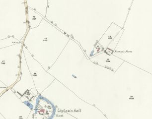
Revision as of 13:43, 27 November 2017 by Hfrancis (talk | contribs) (1885 OS map showing the location of Norney Farm in the parish of Brinkley, Cambridgeshire (in 1886 the land was transferred to the parish of Carlton, Cambridgeshire). The farm was demolished some time after 1956, although some of the buildings had gone...)

Size of this preview: 763 × 600 pixels. Other resolutions: 306 × 240 pixels | 2,357 × 1,852 pixels.
Original file (2,357 × 1,852 pixels, file size: 1.2 MB, MIME type: image/jpeg)
1885 OS map showing the location of Norney Farm in the parish of Brinkley, Cambridgeshire (in 1886 the land was transferred to the parish of Carlton, Cambridgeshire). The farm was demolished some time after 1956, although some of the buildings had gone by 1927.
File history
Click on a date/time to view the file as it appeared at that time.
| Date/Time | Thumbnail | Dimensions | User | Comment | |
|---|---|---|---|---|---|
| current | 13:43, 27 November 2017 | | 2,357 × 1,852 (1.2 MB) | Hfrancis (talk | contribs) | 1885 OS map showing the location of Norney Farm in the parish of Brinkley, Cambridgeshire (in 1886 the land was transferred to the parish of Carlton, Cambridgeshire). The farm was demolished some time after 1956, although some of the buildings had gone... |
You cannot overwrite this file.
File usage
The following page uses this file: